Has Penang Island’s growth & development become a hazard to life?


  • Malaysia’s Penang Island has undergone massive development since the 1960s, a process that continues today with plans for transit and land-reclamation megaprojects.
  • The island is increasingly facing floods and landslides, problems environmentalists link to paving land and building on steep slopes.
  • This is the second in a six-part series of articles on infrastructure projects in Peninsular Malaysia.

GEORGE TOWN, Malaysia — Muddy carpets and soaked furniture lay in moldering piles on the streets of this state capital. It was Sunday morning, Oct. 29, 2017. Eight days earlier, torrents of water had poured off the steep slopes of the island’s central mountain range. Flash floods ripped through neighborhoods. A landslide killed 11 workers at a construction site for a high-rise apartment tower, burying them in mud. It was Penang Island’s second catastrophic deluge in five weeks.

Kam Suan Pheng, an island resident and one of Malaysia’s most prominent soil scientists, stepped to the microphone in front of 200 people hastily gathered for an urgent forum on public safety. Calmly, as she’s done several times before, Kam explained that the contest between Mother Earth’s increasingly fierce meteorological outbursts and the islanders’ affection for building on steep slopes and replacing water-absorbing forest and farmland with roads and buildings would inevitably lead to more tragedies.

“When places get urbanized, the sponge gets smaller. So when there is development, the excess rainwater gets less absorbed into the ground and comes off as flash floods,” she said. “The flood situation is bound to worsen if climate change brings more rain and more intense rainfall.”

Five days later it got worse. Much worse. On Nov. 4, and for the next two days, Penang was inundated by the heaviest rainfall ever recorded on the island. Water flooded streets 3.6 meters (12 feet) deep. Seven people died. The long-running civic discussion that weighed new construction against the risks of increasingly fierce ecological impediments grew more urgent. George Town last year joined an increasing number of the world’s great coastal cities — Houston, New Orleans, New York, Cape Town, Chennai, Jakarta, Melbourne, São Paulo — where the consequences are especially vivid.

The empty apartment construction  site where 11 men died in an October 2017 landslide. Image by Keith Schneider for Mongabay.

Penang’s state government and Chow Kon Yeow, its new chief minister, recognize the dilemma. Three weeks after being named in May to lead the island, Chow told two reporters from The Star newspaper that “[e]conomic growth with environmental sustainability would be an ideal situation rather than sacrificing the environment for the sake of development.”

But Chow also favors more growth. He is the lead proponent for building one of the largest and most expensive transportation projects ever undertaken by a Malaysian city: a $11.4 billion scheme that includes an underwater tunnel linking to peninsular Malaysia, three highways, a light rail line, a monorail, and a 4.8-kilometer (3-mile) gondola from the island to the rest of Penang state on the Malay peninsula.

The state plans to finance construction with proceeds from the sale of 1,800 hectares (4,500 acres) of new land reclaimed from the sea along the island’s southern shore. The Southern Reclamation Project calls for building three artificial islands for manufacturing, retail, offices, and housing for 300,000 residents.

Awarded rights to build the reclamation project in 2015, the SRS Consortium, the primary contractors, are a group of national and local construction companies awaiting the federal government’s decision to proceed. Island fishermen and their allies in Penang’s community of environmental organizations and residential associations oppose the project, and they proposed a competing transport plan that calls for constructing a streetcar and bus rapid transit network at one-third the cost. (See Mongabay –https://news.mongabay.com/2017/04/is-a-property-boom-in-malaysia-causing-a-fisheries-bust-in-penang/)

For a time the national government stood with the fishermen. Wan Junaidi Tuanku Jaafar, the former minister of natural resources and environment and a member of Barisan Nasional (BN), the ruling coalition, refused to allow the project. “The 1,800-hectare project is too massive and can change the shoreline in the area,” he told reporters. “It will not only affect the environment but also the forest such as mangroves. Wildlife and marine life, their breeding habitats will be destroyed.”

The state, and Penang Island, however, have been governed since 2008 by leaders of the Pakatan Harapan coalition, which supported the transport and reclamation mega projects. In May 2018, Pakatan Harapan routed the BN in parliamentary elections. Former prime minister Mahathir Mohamed, the leader of Pakatan Harapan, assumed power once again. Island leaders anticipate that their mega transport and reclamation projects will be approved.

It is plain, though, that last year’s floods opened a new era of civic reflection and reckoning with growth. Proof is everywhere, like the proliferation of huge blue tarps draped across flood-scarred hillsides outside of George Town’s central business district. Intended to block heavy rain from pushing more mud into apartment districts close by, the blue tarps are a distinct signal of ecological distress.

Or the flood-damaged construction sites in Tanjung Bungah, a fast-growing George Town suburb. A lone guard keeps visitors from peering through the gates of the empty apartment construction site where 11 men died in the October 2017 landslide. About a mile away, a row of empty, cracked, expensive and never-occupied hillside townhouses are pitched beside a road buckled like an accordion. The retaining wall supporting the road and development collapsed in the November 2017 flood, causing expensive property damage.

  • A row of empty, cracked, expensive and never-occupied hillside  townhouses are pitched beside a road buckled like an accordion. The retaining wall supporting the road and development collapsed in a November 2017 flood, causing extensive property damage. Image by Keith Schneider for Mongabay.

    Gurmit Singh, founder and chairman of the Centre for Environment, Technology and Development, Malaysia (CETDEM), and dean of the nation’s conservation activists, called Penang state government’s campaign for more growth and mega infrastructure development “a folly.”

    “It exceeds the carrying capacity of the island. It should never be approved,” he said in an interview in his Kuala Lumpur office.

    Singh, who is in his 70s and still active, was raised on Penang Island. He is an eyewitness to the construction that made much of his boyhood geography unrecognizable. “Everything built there now is unsustainable,” he said.

    It’s taken decades to reach that point. Before 1969, when state authorities turned to Robert Nathan and Associates, a U.S. consultancy, to draw up a master plan for economic development, Penang Island was a 293-square-kilometer (113-square-mile) haven of steep mountain forests, ample rice paddies, and fishing villages reachable only by boat.

    For most residents, though, Penang Island was no tropical paradise. Nearly one out of five working adults was jobless, and poverty was endemic in George Town, its colonial capital, according to national records.

    Nathan proposed a path to prosperity: recruiting electronics manufacturers to settle on the island and export their products globally. His plan emphasized the island’s location on the Strait of Malacca, a trading route popular since the 16th century that tied George Town to Singapore and put other big Asian ports in close proximity.

  • Sea and harbor traffic on the Strait of Malacca. Image by Keith Schneider for Mongabay.

    As a 20th century strategy focused on stimulating the economy, Nathan’s plan yielded real dividends. The island’s population nearly doubled to 755,000, according to national estimates. Joblessness hovers in the 2 percent range.

    Foreign investors poured billions of dollars into manufacturing, retail and residential development, and all the supporting port, energy, road, and water supply and wastewater treatment infrastructure. In 1960, the island’s urbanized area totaled 29.5 square kilometers (11.4 square miles), almost all of it in and immediately surrounding George Town. In 2015, the urban area had spread across 112 square kilometers (43 square miles) and replaced the mangroves, rubber plantations, rice paddies and fishing villages along the island’s northern and eastern coasts.

    There are now 220,000 homes on the island, with more than 10,000 new units added annually, according to National Property Information Center. George Town’s colonial center, which dates to its founding in 1786, was designated a UNESCO World Heritage site in 2008, like Venice and Angkor Wat. The distinction helped George Town evolve into a seaside tourist mecca. The state of Penang, which includes 751 square kilometers (290 square miles) on the Malay peninsula, attracts over 6 million visitors annually, roughly half from outside Malaysia. Most of the visitors head to the island, according to Tourism Malaysia.

    Nathan’s plan, though, did not anticipate the powerful ecological and social responses that runaway shoreline and hillside development would wreak in the 21st century. Traffic congestion in George Town is the worst of any Malaysian city. Air pollution is increasing. Flooding is endemic.

  • Blue tarps drape the steep and muddy hillsides in George Town to slow erosion during heavy rain storms. Image by Keith Schneider for Mongabay.

    Nor in the years since have Penang’s civic authorities adequately heeded mounting evidence of impending catastrophes, despite a series of government-sponsored reports calling for economic and environmental sustainability.

    Things came to a head late last year. Flooding caused thousands of people to be evacuated from their homes. Water tore at hillsides, opening the forest to big muddy wounds the color of dried blood. Never had Penang Island sustained such damage from storms that have become more frequent, according to meteorological records. Rain in November that measured over 400 millimeters (13 inches) in a day. The damage and deaths added fresh urgency and new recruits to Penang Island’s longest-running civic argument: Had the island’s growth become a hazard to life?

    George Town is far from alone in considering the answer. The 20th century-inspired patterns of rambunctious residential, industrial and infrastructure development have run headlong into the ferocious meteorological conditions of the 21st century. Coastal cities, where 60 percent of the world’s people live, are being challenged like never before by battering storms and deadly droughts. For instance, during a two-year period that ended in 2016, Chennai, India, along the Bay of Bengal, was brutalized by a typhoon and floods that killed over 400 people, and by a drought that prompted deadly protests over water scarcity. Houston drowned in a storm. Cape Town is in the midst of a two-year drought emergency.

    George Town last year joined the expanding list of cities forced by Nature to a profound reckoning. Between 2013 and mid-October 2017, according to state records, Penang recorded 119 flash floods. The annual incidence is increasing: 22 in 2013; 30 in 2016. Residents talk about a change in weather patterns for an island that once was distinguished by a mild and gentle climate but is now experiencing much more powerful storms with cyclone-force winds and deadly rain.

    Billions of dollars in new investment are at stake. Apartment towers in the path of mudslides and flash flooding rise on the north shore near George Town. Fresh timber clearing continues apace on the steep slopes of the island’s central mountain range, despite regulations that prohibit such activity. Demographers project that the island’s population could reach nearly 1 million by mid-century. That is, if the monstrous storms don’t drive people and businesses away — a trend that has put Chennai’s new high-tech corridor at risk.

    The urgency of the debate has pushed new advocates to join Kam Suan Pheng at the forefront of Penang Island’s environmental activism. One of them is Andrew Ng Yew Han, a 34-year-old teacher and documentary filmmaker whose “The Hills and the Sea” describes how big seabed reclamation projects on the island’s north end have significantly diminished fish stocks and hurt fishing villages. High-rise towers are swiftly pushing a centuries-old way of life out of existence. The same could happen to the more than 2,000 licensed fishermen and women contending with the much bigger reclamation proposals on the south coast.

    “How are they going to survive?” Han said in an interview. “This generation of fisherman will be wiped out. None of their kids want to be fisherman. Penang is holding a world fisherman conference in 2019. The city had the gall to use a picture of local fisherman as the poster. No one who’s coming here knows, ‘Hey you are reclaiming land and destroying livelihood of an entire fishing village.’”

    “We all want Penang to be progressive. To grow. To become a great city,” he adds on one of his videos. “But at whose expense? That’s the question. That’s the story I’m covering.”

  • Andrew Ng Yew Han, a 34-year-old teacher and documentary film maker whose “The Hills and the Sea” describes how big seabed reclamation projects on the island’s north end have significantly diminished fish  stocks and hurt fishing villages. Image by Keith Schneider for Mongabay.

    Another young advocate for sustainable growth is Rexy Prakash Chacko, a 26-year-old engineer documenting illegal forest clearing. Chacko is an active participant in the Penang Forum, the citizens’ group that held the big meeting on flooding last October. Nearly two years ago, he helped launch Penang Hills Watch, an online site that uses satellite imagery and photographs from residents to identify and map big cuts in the Penang hills — cuts that are illegal according to seldom-enforced state and federal laws.

    Kam Suan Pheng and other scientists link the hill clearing to the proliferation of flash flooding and extensive landslides that occur on the island now, even with moderate rainfall.

    In 1960, Malaysia anticipated a future problem with erosion when it passed the Land Conservation Act that designated much of Penang Island’s mountain forests off-limits to development. In 2007, Penang state prohibited development on slopes above an elevation of 76 meters (250 feet), and any slope with an incline greater than 25 degrees, or 47 percent.

    Images on Penang Hills Watch make it plainly apparent that both measures are routinely ignored. In 2015, the state confirmed as much when it made public a list of 55 blocks of high-rise housing, what the state called “special projects,” that had been built on hillsides above 76 meters or on slopes steeper than 25 degrees. The “special projects” encompassed 10,000 residences and buildings as tall as 45 stories.


Rexy Prakash Chacko, a 26-year-old engineer who helped launch Penang Hills Watch, an online site that uses satellite imagery and photographs from residents to identify and map big cuts in the Penang hills. Image by Keith Schneider for Mongabay.

“There is a lot of water coming down the hills now,” Chacko said in an interview. “It’s a lack of foresight. Planning has to take into account what happens when climate change is a factor. Clearing is happening. And in the last two years the rain is getting worse.

“You can imagine. People are concerned about this. There was so much lost from the water and the mud last year.”

Ignoring rules restricting development has consequences, as Kam Suan Pheng has pointed out since getting involved in the civic discussion about growth in 2015. After the October 2017 landslide, she noted that local officials insisted the apartment building where the 11 deaths occurred was under construction on flat ground. But, she told Mongabay, an investigation by the State Commission of Inquiry (SCI) found that the apartment construction site abutted a 60-degree slope made of granite, which is notoriously unstable when it becomes rain-saturated.

“State authorities continued to insist that development above protected hill land is prohibited,” Kam said in an email. “There is little to show that more stringent enforcement on hill slope development has been undertaken. Hopefully the findings of the SCI will serve as lessons for more stringent monitoring and enforcement of similar development projects so that the 11 lives have not been sacrificed in vain.”


Penang Forum calls to review Penang mega projects


Penang Forum members paying a courtesy call on Chow, seated at the head of the table, at his office in Komtar.

Revise transport master plan because circumstances have changed

” A new public transport design has to be integrated to encourage walking, cycling and bus uise – Penang Forum”

THE Penang Forum steering committee, a loose coalition of non-political civil society groups, has called on the Pakatan Harapan Penang government to review the Penang Transport Master Plan (PTMP) estimated to cost RM46bil.

It said the Penang government should bear in mind its election manifesto of balancing economic growth with environmental protection and a commitment to improve public transport.

“Given the scale of the funding for this mega project, the state must ensure government procurement produces the best value for taxpayers’ money.

“The awarding process used was based on a Request for Proposal, rather than a true open tender, which did not allow for any meaningful comparison of bid documents as the scope of work was not fixed.

“Hence the award process must also be reviewed and revisited,” the statement read.

The committee also pointed out that the present PTMP was based on the assumption that buses, ferries and a cross-channel bridge were under federal control and there was nothing much the state could do.

“So it did not focus on how these could be improved or expanded. But now that circumstances have changed, the plan needs to be revised,” it said.

The committee also said the planning for equitable public transport should take into consideration the following criteria:

  • Fiscal prudence that should consider cost-effectiveness in construction, operation and maintenance.Detailed financial analysis of different public transport systems must be done and compared. The most cost-effective system should be selected.
  • Other important considerations are efficiency of operation, predictable schedules and systems compatibility.
  • The different components of the transport system must be well connected and integrated, socially inclusive, with a low impact on the built and natural environment.
  • Extensive public consultation at every stage, with plans available for online viewing and download so that more people can view and comment. It must be carried out and the exercise must be open to scrutiny.
  • Independent consultants who are at the forefront of designing equitable, sustainable transport must be engaged to do the review of the plans. They must not be associated with or employed by parties involved in tendering for the project.

The statement also read that the 2016 transport proposal was a mega project put forward by SRS Consortium, the project delivery partner of PTMP, to the Penang government.

“The design and planning fails to meet most of the above criteria.

“The overpriced package includes many components of mega road building that will discourage people from using public transport and undermine the stated goal of increasing public modal share of transport.

“Although public consultations have been held about impacts in specific localities, open scrutiny of the whole design was strongly discouraged,” the statement said.

The committee also said the original PTMP by Halcrow involved public consultation, but the state pressured the consultants to add the undersea tunnel and three highways costing a total of RM6.3bil just before it adopted the plan in 2013.

The SRS proposal costing RM46bil includes a proposal to reclaim 4,500 acres of land (comprising three islands). It departs drastically from the officially adopted 2013 Halcrow masterplan.

“Thus, a thorough, proper and independent review should be carried out to ascertain its suitability, viability and sustainability.

“The massive proposed reclamation will destroy fishing grounds and jeopardise fishing livelihoods and a vital local source of seafood.

“It will be environmentally unsustainable due to expensive maintenance costs required for dredging in the future.

“Promise 10 of the Pakatan manifesto talks of ensuring food security and protecting the welfare of farmers and fishermen.

“Last but not the least, with rapid changes in public transport technology and new trends in info-mobility, it is imperative that any existing plan for public transport should be re-examined.

“A new public transport design has to be integrated to encourage walking, cycling and bus use,” it said.

Chief Minister Chow Kon Yeow was earlier reported saying that the state government would leave the decision to review the components of the PTMP to the Federal Government.

He said this was because the proposal was at the Federal level right now, adding that if there was any need to review the project, the Federal Government could make a decision.

He also said the SRS Consortium would be happy to supply the Federal agencies with additional details. – Starmetro


Related:

CM: Transport plan components will be fully funded – Metro … 


Call for review of mega project: Penang transport masterplan – Aliran

Time to review RM46 bil Penang Transport Master Plan | Free …

CAP calls for review of Penang mega projects


Residents: Trees to be felled are healthy

Some of the trees along Jalan Loh Poh Heng in Tanjung Bungah,

NGOs hugged wrong trees, says Penang mayor | Free Malaysia Today

The Star on Twitter: “NGOs pleased with council’s explanation over …

NGOs pleased with council’s explanation over felling of trees


Related posts:


Penang Forum Planning for Penang’s Future


Penang new Chief Minister taking Penang to the next level


Penang’s eight transport plans unfulfilled, Not even one commenced work, says Teng


Penang govt shocked at payment of RM22m to Datuk Seri to cover-up alleged corruption in undersea tunnel project.


Opening up a can of worms from Penang Undersea Tunnel project to Ayer Hitam … 


More worms open up from Penang Undersea Tunnel project as Datuk Seri photos hots up

Penang has confirmed the illegal hill clearing cases reported by Penang Forum


Hills, landslides, floods and damaged houses: What to do?


Penang Forum tells Chief Minister: the unmitigated disasters on hill projects


Hills clearing in Penang: NGOs not impressed with mitigation work at Botak Hill


IJM hill clearing & Trehaus construction damaged nearby houses since 2014 must be mitigated quickly!


Penang Island City Council, MBPP councilor Dr Lim fed up change not happening in Penang

Huge landslide in Tg Bungah hill


Disaster zone: An aerial view of the recent landslide in Tanjung Bungah, Penang.
An aerial view of the brown water flowing into the sea from Sungai Kelian.

GEORGE TOWN: Nobody knew a natural disaster was waiting to happen until Sungai Kelian in Tanjung Bungah turned brown and silty.

The sudden profusion of laterite mud flowing out to sea was caused by a landslide even bigger than the one that killed 11 people at a Tanjung Bungah construction site last year.

But it was so far uphill – 231m above sea level – that Penang Island City Council (MBPP) had to use a drone to find it.

As it was a natural landslide, residents are now worried about the fragility of slopes in the Tanjung Bungah hill range and want tighter scrutiny on the many development projects slated for their neighbourhood all the way to Batu Ferringhi.
MBPP issued a statement on Sunday after discovering the landslide on Bukit Batu Ferringhi, in the forest reserve about 1.5km uphill of a disused Penang Water Supply Corporation (PBAPP) intake station.

PBAPP chief executive officer Datuk Jaseni Maidinsa clarified that the station had not been in use since 1999, after the Teluk Bahang Dam was completed.

An MBPP engineer said the landslide was about 40m long and 20m wide, but geo-technical experts were unable to reach the site to determine what happened because there are no jungle trails to reach it.

A group called Nelayan Tanjung Tokong shared a video on Facebook last Thursday, showing the russet brown water flowing into the sea from Sungai Kelian and expressed concern.

Tanjung Bungah Residents Asso­ciation chairman Meenakshi Ra­­man said it was worrying because the landslide happened without any human disturbance.

“It shows the hills in the vicinity are ecologically fragile, and we don’t want any untoward incidents to happen again.

“We hope the authorities will tell us what is being done to prevent further landslides,” she said yesterday.

Former Tanjung Bungah assemblyman Teh Yee Cheu said he knew the area well and believed that the landslide took place near the source of Sungai Kelian.

“I have always stressed on how sensitive the hill slopes here are. There are many underground springs in the hills,” he said.

State Works, Utilities and Flood Mitigation Committee chairman Zairil Khir Johari said the landslide happened in the middle of a forest reserve and experts need time to study the slope to understand how it gave way.

He gave an assurance that the mud washing down the river would clear up in due course without long-term damage.

Zairil also stressed that no deve­lopment had been approved near the landslide area.

“The state government’s guidelines on hill slope development are tighter than those used by the Federal Government. We will not approve developments without pro­per compliance,” he added.

Penang Drainage and Irrigation Department director Mohd Azmin Hussin said that it would be difficult to transport machinery to the source of the landslide for mitigation works.

“There are no access roads and the team will have to hike to the site,” he said. – The Star

Related posts:


Don’t allow another landslide tragedy to happen !


NGO draws up own manifesto to assist the next state government  (From left) Anil, Ben, Dr Chee, Khoo Salma, Dr Anwar and Dr Ka…
Halt all hillslope development, Penang Forum tells state | Free … FMT – GEORGE TOWN: The Penang Forum has repeated its call for al..

Penang govt rapped over hill slope development


FMT – GEORGE TOWN: The Penang Forum has repeated its call for all hillslope development to be stopped immediately, following deadly hillslope collapse ...
Geotechnical engineer Aziz Noor says the new project puts the people and the place in danger


Engineer: Lives at risk in Penang hill project


GEORGE TOWN: The DAP-led state government has turned a blind eye on the imminent danger of hill slope development, said a Tanjung Bungah resident.

At a forum-cum-press conference yesterday, geotechnical consultant Aziz Noor (pic) said building the proposed multi-storey mixed development behind the Miami Green Resort Condominium would pose a danger to the condo and its residents.

The development which has been approved on the class four hill, comprises five 29-storey building blocks, two 34-storey serviced apartments with 336 units each and one block of affordable apartments with 197 units.

Meanwhile, former Bukit Bendera MP Zairil Khir Johari, who is the Tanjong Bungah candidate for Pakatan Harapan, said the state government would review the guidelines on hill slope development. – Bernama


GEORGE TOWN: An engineer has sounded a warning about “imminent danger” from a new hillside development of eight tower blocks of apartments planned in an environmentally-sensitive area of Tanjung Bungah.

Geotechnical consultant Aziz Noor, speaking at a forum-cum-press conference today, accused the DAP-led state government of turning a blind eye on the imminent danger of hill slope development.

The proposed mixed development behind Miami Green Resort condominium puts the existing residence and its people in danger, he said.

The development has been approved on a 12-acre plot with a 35-degree slope on a Class Four hill, which exceeds 250 feet above sea level.

It comprises five 29-storey tower blocks, two 34-storey blocks of 336 serviced apartments each, and one block of 197 units of affordable apartments.

Aziz said that the project was not only in an environmentally sensitive area, it also contradicts the 2007 Penang Structure Plan that forbid any development above a gradient of 25-degree gradient and 250 feet above sea-level.

The design of one development does not guarantee safety. A Detailed Environmental Impact Assessment must be conducted and reviewed. This development puts the place and people in imminent danger,” he said.

Residents of the area said they had vented their frustration multiple times since November but had not received any response from the state government and Penang Island City Council.

The residents, together with the Tanjung Bunga residents association, had spoken on the matter many times, but no one seemed bothered, said one of the residents, Lim Liew Ming.

“Our lives are at risk. The upcoming development is a ticking time-bomb. Are the authorities waiting for a tragedy to happen, and only then act on it?,” she asked.

State Barisan Nasional chairman Teng Chang Yeow, who is also BN candidate for the Tanjong Bunga state seat in the general election, said the project should have been shelved from the beginning.

“We will put a stop to this. Even if we need to pay compensation,” he said.

The Barisan Nasional has pledged to declare all highland and hill slope areas of 250 feet above sea-level as permanent forest reserve.

Former Bukit Bendera MP Zairil Khir Johari, who is the Pakatan Harapan candidate for Tanjong Bunga, said the state government would review the guidelines on hill slope development.

Source:FMT.Click here to get live updates throughout the GE14 season


GEORGE TOWN: An MCA state leader has criticised Penang Chief Minister Lim Guan Eng over the latter’s statement that more stop-work orders have been issued against hillside development by the current state government.

State MCA Wanita chairman Tan Cheng Liang said Lim, who is also the DAP secretary-general, had “conveniently avoided” revealing the increase in number of protests in the state since 2008.

“He boasts about more stop-work orders being issued now compared to when Barisan Nasional was helming the state government.

“However, he failed to reveal that there have been more protests by Penangites against hillside development since Pakatan Rakyat took over.

“The latest is the chorus of dissatisfaction by residents of Mount Pleasure in Batu Ferringhi, objecting against approval accorded by the Penang Municipal Council (MPPP) for the construction of 21 four-storey villas and 80 two-storey bungalows there,” she said.

She said the 2008 DAP general election manifesto unveiled by Lim promised to “preserve our forest, wetlands and bio-diversity” while Pakatan Rakyat’s common policy framework stressed that the “environment must be preserved for the sustainability of future generations.”

“Just six weeks ago, Lim said in a speech that the Pakatan government was proud of its record of not approving any hillside development.

“However, the voices of disapproval by Penangites are evidence that Lim, the DAP and Pakatan are deceptive,” she claimed.

Citing examples, she said on April 8 this year, Sungai Ara residents protested against approval issued by MPPP Planning Department for two hillside development projects and in February 2009, Tanjung Bungah residents protested and submitted a memorandum calling on the state government to ban all current and future Class III and Class IV hillslope development projects.

“In view of these protests and to deliver the DAP and Pakatan’s pledge to protect the environment, I challenge Lim and the state government to issue a stop-work orders against all hillside development projects approved by MPPP,” she said in a press release yesterday.

Tan also took a swipe at Lim for focusing on luxury residences but allegedly had no regard for the poor.

“Approvals are given for exclusive housing and condominium projects on hills, but scant attention is given to low-cost housing for the poor where no low or medium cost units were constructed between 2008 to 2011,” she claimed.

On Tuesday, Lim said more stop-work orders had been issued by both local councils since 2008 compared to previously.

He said this proved that the state government was “more stringent in upholding the rule of law, demanding strict compliance with technical requirements and more unforgiving than Barisan.” – The Star

Related articles:

Zairil under fire over high-rise – Nation

Uphill battle: Miami Green Resort Condominium residents protesting against the upcoming hillside project located behind their high-rise.

Jagdeep: Project behind condo not 76m above sea level as claimed

Penang government needs ‘check and balance’ – Malaysian Chinese …


Now Bukit Jambul hit by hill-clearing more than 250 feet above sea level

anilnetto.com › Economy › Development issuesAug 26, 2016 – This is apparently for a condo and semi-detached housing project by a major property developer. The site lies along Lebuh Bukit Jambul, on the hillslopes

just north of Inti College and near Equatorial Hotel in Bukit Jambul. The irony is that such ‘back to Nature’ projects are being advertised as ‘green …

Southern Bukit Jambul – READ MORE:  Penang Forum discusses its Penang Hills Watch Report 2016 with state government


READ MORE:  Penang Forum 8: Dialogue on floods – a call to action (videos)


 DAP rep slams state govt over hillslope project, Malaysia News …

The DAP state assemblyman for Tanjung Bungah has hit out at state authorities for approving another hillslope project on the … They were concerned about the possible violation of law related with hillslope development guidelines by either the developer or the state government, or both.
Related posts:

NGO draws up own manifesto to assist the
next state government  (From left) Anil, Ben, Dr Chee, Khoo
Salma, Dr Anwar and Dr Ka…

Penang landslide tragedy, why it happened?

Speaking out: Penang Forum members protesting outside the CAP office in George Town. Don’t just make it about worker safety issues …

Behind BJ Cove houses at Lintang Bukit Jambul 1 is an IJM Trehaus Project.  Approximate Coordinates : 5°20’38.47″N,100°16’…

Penang floods and landslides, looking beyound natural causes! Seeking solutions: Penang Forum member and soil expert Dr Kam Suan Pheng giving her views during the dialogue session themed ‘Penang Fl..

Penang hit by floods again !

https://youtu.be/ooyXvqmxbvw GEORGE TOWN: Some 20 houses located on a slope in Hong Seng Estate in Mount Erskine were flooded due


It’s hard to deny when the effects of climate change are all around us  Andrew Sheng says that from increasingly intense hurricanes t…

Hills, landslides, floods and damaged houses: What to do?

https://youtu.be/kslhytLg-Wc Hills, landslides and floods: What to do?   The mega floods in Penang which followed the landslide…
Choong (in white) surveying the deforested hillslope next to Majestic Heights. PENANG MCA has raised concerns about the safety of the r…


Wet, wet woes: (Above) Bukit Jambul is flooded once again after an evening downpour. Firemen installing a pump to draw floodwater…


Council should not bow to development or political pressure, says city councilor, Khoo ‘Politicians should be ‘wakil rakyat’ and n…
(From left) Dr Kam will deliver a talk on ‘Understanding the Causes of Floods and Seeking Solutions. State assemblymen expressing inter…
https://youtu.be/4qaOB1n5tgA GEORGE TOWN: The Penang Island City Council has lodged a police report against the consultant of the aff…


https://youtu.be/QB45Q2_mOG0 Suspicious activity: A photo taken from Penang social activist Anil Netto’s blog showing an active s..


Becoming bald: A view of the clearing work seen at Bukit Relau which was visible from the Penang Bridge in November last year. GEORGE..


  Fake Awards Scam for Penang Island City Council, Seberang Perai Municipal Council ! 

Home locked by Penang City Council over RM468 paltry arrears of assessment 

Absorb New ways to prevent floods


Sponge City: Solutions for China’s Thirsty & Flooded cities

 China’s ‘sponge city’ projects may be worthwhile examples for Malaysia.

“Only about 20~30% of rainwater infiltrates the ground in urban areas, so it breaks the naturual water circulation.– Wen Mei Dubbelaar”

Last week, it was the turn of Petaling Jaya, Gombak and Sungai Buloh to be the latest major urban areas in Malaysia to suffer flash floods (Flash floods wreak havoc in PJ – Nation). Scenes of cars and buildings submerged in muddy water are now almost an everyday thing. The focus should now shift from the bad situations to the solutions.

It was also last week that I attended a briefing organised by civil society groups for Penang and Seberang Perai municipal officials and members. The briefing was on the recent floods.

Later, I came across several articles on how China is turning 30 of its flood-prone areas into “sponge cities” to prevent floods and retain rainwater.

The Chinese plan big and fast. It launched the sponge city project only in 2015, but it aims to retain 70% of rain in 80% of urban areas by 2020. The sponge concept is set to spread rapidly as part of global efforts to reduce the impact of increased rainfall and floods, and climate change.

The concept figured prominently at the briefing chaired by Penang state exco member Chow Kon Yeow. Scientist Dr Kam Suan Pheng introduced it when explaining the floods.

She contrasted the present situation when rain falls with what used to happen. In the past, 50% of the rain seeped through the natural ground cover (trees, grass, etc) and into the ground. There was 10% water runoff (to rivers and drains) and 40% evapotranspiration (water going back to the atmosphere).

The trees and green spaces act as a sponge to absorb the rainwater that infiltrates the soil, preventing the water from building up into flash floods.

Due to urbanisation, the green spaces have been paved over with cement and concrete. Now, only 15% of the rain infiltrates the soil, while the runoff has increased to 55% and evapotranspiration is 30%. The sponge now absorbs 15% of the rainwater compared to the previous 50%.

Dr Kam quoted former Penang Water Authority general manager Kam U-Tee as saying that the October 2008 Penang floods were caused by conversion of the valleys into “concrete aprons that do not retain water”. As a result, the water immediately flowed into streams, causing flash floods, even with moderate rainfall.

Given this analysis, a key part of tackling the floods is to reverse the loss of the sponge. In recent decades, Malaysia has seen the conversion of a lot of farms, parks, trees and grass areas into concrete jungles of roads, houses, commercial buildings and car parks.

There now has to be high sensitivity to the valuable environmental and economic roles of trees, gardens, fields and grasslands, and parks. The aim of garden cities is not just to be pleasing to the eye but to be a very important part of development as well.

Now comes the role of sponge cities. The world is applauding the Chinese initiative to counter floods and improve water security by building up the natural cover (or sponge) in its cities.

In 2010, landslides during flooding killed 700 in three quarters of China’s provinces. Last year, rains flooded southern China, destroying homes and killing around 60 people.

In 2015, China launched the Sponge City initiative, which now covers 30 cities, including Shanghai, Xiamen and Wuhan. The target: by 2020, 80% of its urban areas will absorb and re-use 70% of rainwater.

The many types of projects include:

  • > Constructing permeable roads that enable water to infiltrate the ground;
  • > Replacing pavements on roads and parks to make them permeable;
  • > Building wetlands to absorb and store rainwater;
  • > Constructing rooftop gardens (for example, 4.3 million square feet in Shanghai);
  • > Plant trees on streets and public squares;
  • > Build community gardens and parks to expand green spaces; and
  • > Build manmade lakes and preserve agricultural land to hold water.

“In the natural environment, most precipitation infiltrates the ground or is received by surface water, but this is disrupted when there are large-scale hard pavements,” said Wen Mei Dubbelaar, water management director at China Arcadis, in words similar to Dr Kam’s.

“Now only about 20-30% of rainwater infiltrates the ground in urban areas, so it breaks the natural water circulation and causes water logging and surface water pollution,” said Wen in an interview with The Guardian.

In Shanghai’s Lingang district, the streets are built with permeable pavements. There are rain gardens filled with soil and plants, buildings feature green rooftops and water tanks, and a manmade lake controls water flows, reports The Guardian.

Prof Hui Li at Tongji University said the first thing is to preserve or restore natural waterways as that is the natural way to reduce flooding risk.

The problem in Wuhan is that a lot of small rivers were filled in during building. But Lingang still has agriculture land and a lake to hold more water during heavy rain.

What about the cost factor? So far the cities have received over US$12bil (RM47.4bil) for sponge projects. The central government funds 15-20% of costs, and the rest is from local governments and private developers.

But compare this to the US$100bil (RM395bil) of direct economic losses due to floods in China between 2011 and 2014, plus the human lives lost.

Sponge cities are the way to go for the future. Our own governments – federal, state and municipal – should study this option seriously, as the public braces itself for more floods ahead.

– Global Trends by Martin Khor

Martin Khor is executive director of the South Centre. The views expressed here are entirely his own.
Related Links


10 measures to prevent (urban) flooding – Wavin

Related posts:


Our Environment is Our Life – YouTube THE year has barely started, and already we have so many reports of weather and climate-related e…
Seeking solutions: Penang Forum member and soil expert Dr Kam Suan Pheng giving her views during the dialogue session themed ‘Penang Fl… 

Behind BJ Cove houses at Lintang Bukit Jambul 1 is an IJM Trehaus Project.  Approximate Coordinates :
5°20’38.47″N,100°16’…

PAC blamed Penang Island City Council (MBPP) for failing to enforce laws on hillside development
Becoming bald: A view of the clearing work seen at Bukit Relau which was visible from the Penang Bridge in November last year. GEORGE..


Speaking out: Penang Forum members protesting outside the CAP office in George Town. Don’t just make it about worker safety issues ..

https://youtu.be/kslhytLg-Wc Hills, landslides and floods: What to do?   The mega floods in Penang which followed the landslide…


https://youtu.be/yqtdkBsipCU Suspicious activity: A photo taken from Penang social activist Anil Netto’s blog showing an active s..

Penang Landslide occured days after remedial works started


Cracks at Tanjung Bungah site began in June, Commissioner of Inquiry told

Expert panel: (From right) Yeo, Dr Gue and Prof Ramli arriving for the inquiry.

GEORGE TOWN: A temporary structure supporting a worksite slope in Tanjung Bungah developed cracks in mid-June, a Commissioner of Inquiry heard.

Soil Mechanic Sdn Bhd director Cheah Wing How, who was a sub-contractor of the project where a landslide killed 11 workers, said he was informed by a clerk to carry out remedial works as the granite wall had cracked.

Cheah said his team left after completing the granite works and soil-nailing works to enhance the stability of the temporary slope.

There was, however, no mention when they completed the works.

“When we returned, we found there were pile cap excavation works carried out near the slope.

“We believe there was soil movement that resulted in the cracks on the granite wall.

“We were carrying out remedial works and 11 days into the job, the landslide happened,” said Cheah, who has 20 years’ experience in the field.

Cheah was testifying on the first day of the public hearing into the landslide tragedy by the State Commission of Inquiry (SCI) at City Hall in Esplanade yesterday.

On Oct 21, last year, a landslide hit the affordable condominium project made up of two 49-storey towers with 980 units in total within the Permai Village township near the Tunku Abdul Rahman University College.

Among the 11 killed was site supervisor Yuan Kuok Wern, 27.

During the proceeding, the Penang Island City Council (MBPP) also presented eight drone videos that showed the slope and the surrounding area after the tragic incident.

SCI chairman Datuk Yeo Yong Poh said they planned to carry out a site visit tomorrow.

He also fixed the hearing to continue until Monday, followed by Feb 8 to Feb 11, March 24 to March 28 and April 18 to 25.

Other members of the commission are geotechnical expert Datuk Dr Gue See Sew and forensic geo-technical engineer from Universiti Teknologi Malaysia Prof Ramli Nazir.

The SCI was gazetted on Dec 21 last year to investigate the landslide after Yang di-Pertua Negri Tun Rahman Abbas gave his consent on Dec 6, 2017, for the appointment of the members of the commission and its terms of reference.

Meanwhile, Penang Citizens Awareness Chant Group (Chant) adviser Yan Lee said the entrance to the Teik Granite Quarry, which is located near the site where the landslide occurred, should be fenced up.

“Anyone can just walk into the site as the safety measure is not up to mark.

“We have voiced our concern to the Penang Island City Council, the Department of Environment as well as the Land and Mines Department,” he said yesterday.

By Chong Kah Yuan and Jo-Leen Wong The Star

Related Links:

Contractors in jitters over temporary slopes – Nation

Boulders slid down hill prior to disaster – Nation

//players.brightcove.net/4405352761001/default_default/index.html?videoId=5719810415001
Related posts:

Penang landslide tragedy, plea went unheeded, no one listened !

Behind BJ Cove houses at Lintang Bukit Jambul 1 is an IJM Trehaus Project.  Approximate Coordinates : 5°20’38.47″N,100°16′..

Wanted: Leaders who listen !


Turning a blind eye: The grumblings over exposed hills are growing louder but little is being done to rectify the situation

//players.brightcove.net/4405352761001/default_default/index.html?videoId=5636613745001

 Grievances from residents warning of environmental damages must not fall on deaf ears

 “Leaders who don’t listen will eventually be surrounded by people who have nothing to say.

MY family home in Kampung Melayu, Air Itam in Penang, is more than 56 years old. That’s about my age, and it has never been hit by floods. Not once!

But last week, my parents – dad is 92 years old and mum, 86, – had their sleep rudely interrupted sometime after 1am by water gushing into their home.

They have been sleeping on the ground floor for years now because they are too old to climb the stairs to their bedroom.

The water that flowed into their room almost touched the top of their bed but fortunately, one of my nephews and his wife from Kuala Lumpur were staying over that night.

It was so fortunate that they were there to calm my anxious parents down and assure them all would be fine. They managed to comfort my stunned folks, who had never experienced such an unpleasant situation before. My father had to be carried to the room upstairs as the house remained flooded throughout the early morning.

Our home was filled with layers of mud the next day and the cars parked outside were all damaged. They sadly look like write-offs.

My father’s pride and joy, his first-generation Proton Saga car – which he bought in 1985 – is now unusable.

A week on, my brothers and nieces are still cleaning up the mess from the massive flood. They haven’t had the time or mood to even assess the financial losses.

And bound by a common sentiment as Penangites, they are tired of the blame game, a trade the state’s politicians have plied to near-perfection.

How many times can the finger be pointed at the previous government, with the incumbent almost 10 years in power? And how many more times can we blame it on torrential rain, which came from Vietnam – or wherever? Worst of all is, when discussions are mooted on flood issues, the voices of the people are swiftly silenced.

It appears that even to talk about hillslope development, one would have to contest in the elections, or be perceived to be challenging the state government, or more extremely, be some kind of lackey in cahoots with the Federal Government.

Blaming everyone else except oneself is simply a way of covering up one’s weaknesses. But the discerning public, in a maturing democracy with heightened transparency and a huge middle class like Penang, will not tolerate such short-term manoeuvring for long.

Suddenly, civil society – a buzzword among politicians – has vanished, with NGOs now regarded as irritants and an affront to the state establishment. Politics is apparently the monopoly of politicians now.

As the National Human Rights Society aptly puts it, “With the benefit of hindsight, we are sure that the Penang government now realises that they should not so readily malign civil society, howsoever obliquely – for the legitimate and well-founded articulation of matters of great concern to civil society.

“This is because it undermines the fundamental values of a functioning democracy and the fundamental human rights of the populace at large.”

Perhaps, the state political elites, many of whom aren’t pure blood Penangites, don’t realise the state is the home of a vibrant civil society, with many active NGOs and activists who are respected influencers of society.

Having walked through the corridors of power and appreciated power’s pleasures, perks and the adulation it brings, maybe it is becoming much harder for people to take criticism. This is, in fact, a reflection of the arrogance of power.

Many have developed thin skin now, with little tolerance for the slightest form of criticism. If anyone even dares raise their voice, an army of cybertroopers, hiding behind anonymity, are unleashed to attack them.

Freedom of speech, it seems, is only the domain of the opposition, with some media (regarded as unfriendly) unceremoniously ridiculed and questioned for their attendance at press conferences.

There are politicians from the Federal Government, too, who are shamelessly cashing in on the flood situation in Penang.

Their relief work must be splashed across news pages, and they have to be seen wading through the flood waters for dramatic purpose. Phua Chu Kang’s iconic yellow boots could likely be the hottest item in the state, as politicians bask in the media’s glare.

Ridiculous remarks have also been passed, one even blaming the state government, saying it has earned the wrath of God.

The rain and floods will go away, eventually. Penangites are stakeholders in the state, and they don’t only make up politicians. The state doesn’t belong to the state government or the opposition.

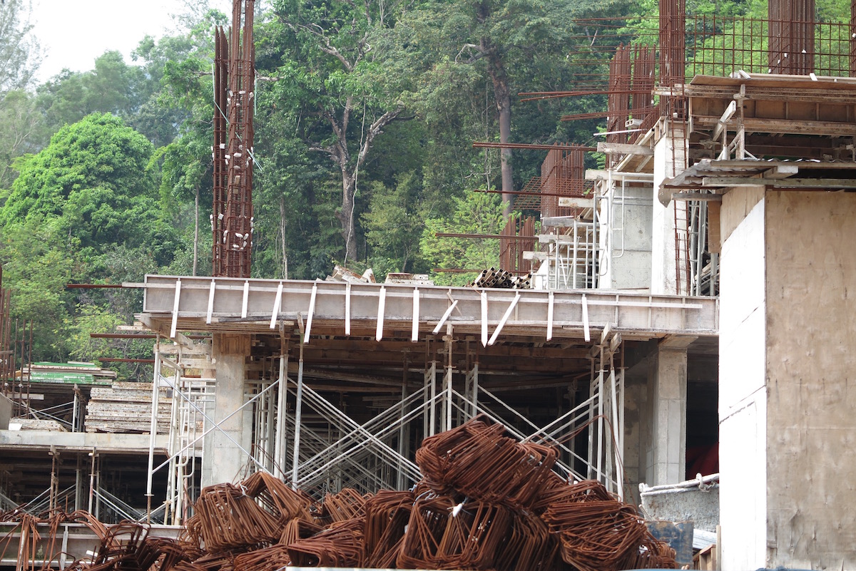
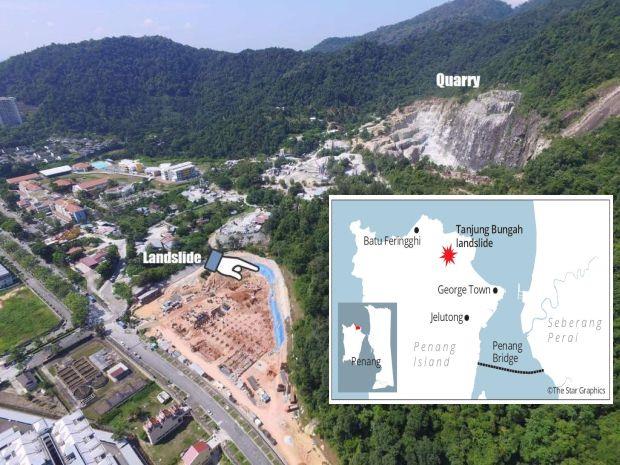
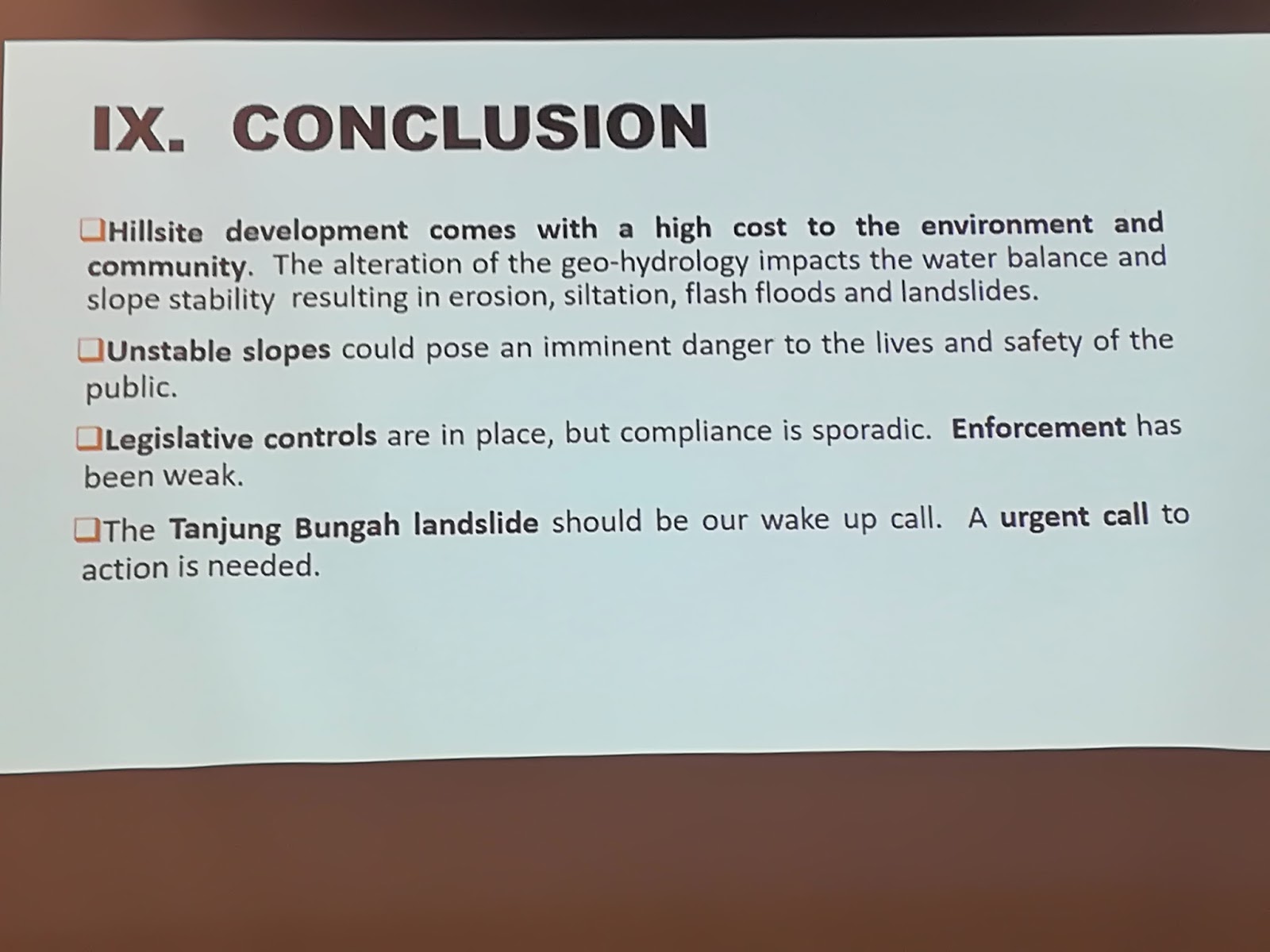
Caught up in the thick of the action, we seem to have forgotten that the hills are crumbling even without rain. As a stern reminder, just last month, a landslide buried some people in Tanjung Bungah. Investigations on that tragedy are still ongoing.

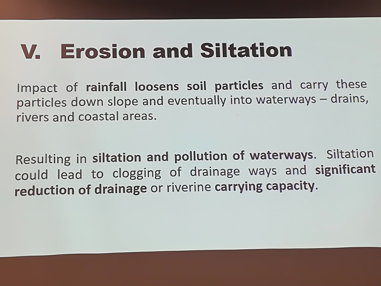
Basically, the trees – which act as sponge on the hills – are gone. We don’t need to be soil experts to know that.

The grumblings are growing louder because the hills have been progressively going bald in recent years. But the voice of discontent has fallen on deaf ears.

Penangites are alarmed at what they are seeing, and they don’t like it one bit, as much as they understand that land is scarce on the island and property developers need to source some to build homes on.

While it’s easy to hang the Penang state government out to dry for its follies, it’s difficult to ignore how the floods in the east coast states have become annual affairs, too. So, what effective flood mitigation plans have been put in place there?

Kelantan has suffered senselessly, and after more than a year of having been subjected to Mother Nature’s havoc, many victims have yet to recover from their losses. Flooding is obviously nothing exclusive and doesn’t discriminate. Every state has, unfortunately, experienced it in some shape or form.

So, irrespective of location, when life returns to normal, you can expect the politicians to resume their old denying ways.

If there’s a thread that binds our politicians – regardless of which side of the political divide they come from – it is their inability to apologise for their mistakes, despite waxing lyrical about accountability.

Don’t expect them to say sorry, because an apology would be admission of guilt, or worse, a sign of weakness in their realm of inflated egos.

And to put things into perspective, perhaps we could learn a lesson from a quote by prominent American pastor Andy Stanley – “Leaders who don’t listen will eventually be surrounded by people who have nothing to say.”
On the beat Wong Chun Wai

Wong Chun Wai began his career as a journalist in Penang, and has served The Star for over 27 years in various capacities and roles. He is now the group’s managing director/chief executive officer and formerly the group chief editor.

On The Beat made its debut on Feb 23 1997 and Chun Wai has penned the column weekly without a break, except for the occasional press holiday when the paper was not published. In May 2011, a compilation of selected articles of On The Beat was published as a book and launched in conjunction with his 50th birthday. Chun Wai also comments on current issues in The Star.

Related posts:

Behind BJ Cove houses at Lintang Bukit Jambul 1 is an IJM Trehaus Project.

Becoming bald: A view of the clearing work seen at Bukit Relau which was visible from athe Penang Bridge in November last year. GEORGE…

https://youtu.be/QB45Q2_mOG0 Suspicious activity: A photo taken from Penang social activist Anil Netto’s blog showing an active s..

Council should not bow to development or political pressure, says city councilor, Khoo ‘Politicians should be ‘wakil rakyat’ and n…
Seeking solutions: Penang Forum member and soil expert Dr Kam Suan Pheng giving her views during the dialogue session themed ‘Penang Fl…
It’s hard to deny when the effects of climate change are all around us  Andrew Sheng says that from
increasingly intense hurricanes t…
Why did MBPP approve the Tanjung Bungah development project? Read more at https://www.malaysiakini.com/letters/399357#qbRd534yu1JfC551….
https://youtu.be/kslhytLg-Wc Hills, landslides and floods: What to do?   The mega floods in Penang which followed the landslide…

Choong (in white) surveying the deforested hillslope next to Majestic Heights. PENANG MCA has raised concerns about the safety of the r..

https://youtu.be/4qaOB1n5tgA GEORGE TOWN: The Penang Island City Council has lodged a police report against the consultant of the aff…

Penang landslides & flooding are natural disasters man-made?


It’s hard to deny when the effects of climate change are all around us


Andrew Sheng says that from increasingly intense hurricanes to regional landslides and flooding, it’s clear our actions are effecting the
environment. But, it’s also evident that there are ways for us to avert
disaster and change course


AFTER two Category 5 hurricanes (Harvey and Irma) hit the US in October, followed by Maria hitting Puerto Rico, no one can deny that natural disasters are devastating.

With three hurricanes costing an estimated US$385bil, with less than half insured, the poor are suffering the most because they cannot afford to rebuild as the rich.

This year alone, monsoon floods in Bangladesh, India and Nepal have left millions homeless. This year will therefore break all records as Munich Re-insurance data suggests that 2016 natural disaster losses were only US$175bil, already 28.6% higher than the 30 years (1986-2015) annual average of US$126bil.

But how much of these natural disasters are man-made?

Despite US President Trump being sceptical of climate change, the US Global Change Research Program Climate Science Report published this month concludes that “it is extremely likely that human activities, especially emissions of greenhouse gases, are the dominant cause of the observed warming since the mid-20th century”.

Carbon dioxide concentration already exceed 400 parts per million, last occurred about 3 million years ago, when both global average temperature and sea level were significantly higher than today. Roughly one third of carbon emission is due to residential heating/cooling, one third for transport and one third for industrial production.

Human activities on Mother Earth include over-consumption of natural resources, cutting down forests, polluting waters and excessive cultivation/development that caused desertification or soil erosion. You see this from warmer surface and oceanic temperatures; melting glaciers; diminishing snow cover; shrinking sea ice; rising sea levels; ocean acidification; and declining tree and fish stock.

Oceans warming up

Hurricanes are caused by oceans warming up, building energy and vapour levels that create freak typhoons, tornados and massive downpours. At the same time, droughts are also occurring with more frequency for longer.

Scientists estimate that global average sea level has risen by about 7-8 inches since 1900, with almost half that rise occurring since 1993. Everyday, we hear new extreme events, such as unusually heavy rainfall, heatwaves, large forest fires, floods or landslides.

Climate warming is most observable in the water-stressed Middle East and the North Africa/Sahel region, where rapid population growth created desertification, food shortages, civil conflicts and ultimately, outward migration towards cooler climates, especially Europe. This hot region accounts for 60% of global war casualties since 2000, with 10 million outward refugees. About 90% of the world’s refugees and asylum seekers come from four regions with half under the age of 18 years.

A 2016 World Bank report estimated that these water-stressed countries’ GDP could be reduced by up to 6%, with dire consequences on stability. Without water, industries cannot function, food cannot be cultivated and health can deteriorate due to disease from water-shortage and drought.

European estimates suggest that each refugee costs roughly US$11,600 per person to maintain and there are already one million trying to enter Europe last year. The OECD has classified countries such as Afghanistan, Central African Republic, Iraq, Somalia, Sudan, Syria and Yemen as extreme fragile.

Critical point

The world is already reaching a critical turning point. If the Paris Climate Accord can be implemented, with or without the United States, there is some chance of averting further global warming.

But closer home, we are already witnessing the effects of climate change on our daily lives.

In 1972, Hong Kong experienced a devastating landslide near Po Shan Road in Mid-Levels, which caused 67 deaths and collapse of two buildings. One cause was unstable ground following heavy rainfall from Typhoon Rose eleven months prior to the incident.

This tragedy in densely populated Hong Kong resulted in rigorous slope protection and inspection of drains to ensure that these slips do not occur again. I lived near Po Shan Road and admired how Hong Kong engineers regularly inspected the slope protection measures and that the drains were always clear.

In 1993, the collapse of Highland Towers in Kuala Lumpur was partly attributed to the clearing of the hilltop above Highland Towers, which led to soil erosion and the weakening of the foundations. By the time the residents detected cracks in the buildings, it was already too late. Some of my personal friends were among the 48 persons who were killed in that collapse.

Last weekend, Penang (where I live) had the worst rainstorm and floods because we were hit by the tail end of strong winds from Typhoon Damrey, one of the strongest to hit Vietnam in 16 years, leaving 61 people dead. Driving along Penang Bridge, I can see that the continued hilltop developments in Penang are leaving soiled scars on the previously pristine landscape, I am reminded of Highland Towers and Po Shan incidents. Natural disasters are acts of god, but the size of their impact on human lives are completely within our control.

Soil erosion

Soil erosion does not happen overnight, and require responsible developers and conscientious governments, as well as concerned citizens, to be continually vigilant that maintenance of roads and drains, including soil inspections, are serious business with serious consequences.

Modern technology can provide drones and inbuilt sensors that can detect whether erosion is reaching critical levels. Regular maintenance of drains and checks on stability of the soil, especially where there has been recent clearing of trees in steep slopes, will forewarn us all of impending accidents.

As cities are building more and more on hillsides subject to torrential rain, Penang should seek technical expertise from Hong Kong which has extensive expertise on the maintenance of steep hill slopes that are subject to typhoons and sudden rainfall.

Landslides are today used more in political terms than in real terms. The next time landslides happen, residents who watch daily the erosion of their natural environment will know who is really looking after their interests.

Andrew Sheng  By Andrew Sheng


Related links:

No hill land approvals since 2008?

by penangforum

Former MBPP councillor Dr Lim Mah Hui wrote this piece for the press in his
personal capacity: I wish to comment on the press statement by Jagdeep
Singh Deo as reported in Berita Daily and many other newspapers on 24
October.

PKR rep cries for a stop to hillside development – Nation

Related posts:


Behind BJ Cove houses at Lintang Bukit Jambul 1 is an IJM Trehaus Project.  Approximate Coordinates : 5°20’38.47″N,100°16’…

Becoming bald: A view of the clearing work seen at Bukit Relau which was visible from the Penang Bridge in November last year. GEORGE

Choong (in white) surveying the deforested hillslope next to Majestic Heights. PENANG MCA has raised concerns about the safety of the r…
Why did MBPP approve the Tanjung Bungah development project? Read more at https://www.malaysiakini.com/letters/399357#qbRd534yu1JfC551….


Becoming bald: A view of the clearing work seen at Bukit Relau which was visible from the Penang Bridge in November last year. GEORGE…

Seeking solutions: Penang Forum member and soil expert Dr Kam Suan Pheng giving her views during the dialogue sessio

Council should not bow to development or political pressure, says city councilor, Khoo ‘Politicians should be ‘wakil rakyat’ and n…
https://youtu.be/kslhytLg-Wc Hills, landslides and floods: What to do?   The mega floods in Penang which followed the landslide…

Speaking out: Penang Forum members protesting outside the CAP office in George Town. Don’t just make it about worker safety

https://youtu.be/QB45Q2_mOG0 Suspicious activity: A photo taken from Penang social activist Anil Netto’s blog showing an active

GEORGE TOWN: Penang has tabled a higher deficit state Budget of RM740.5million for the next fiscal year of 2018. Chief Minister Lim Guan …
Humans Are Destroying the Environment   PETALING JAYA: They are supposed to be guardians of the environment, and yet “certain enforcem..

Hills, landslides, floods and damaged houses: What to do?


Hills, landslides and floods: What to do?

 The mega floods in Penang which followed the landslide tragedy, flash floods in Kuala Lumpur and Petaling Jaya, and a shrinking water catchment area in Ulu Muda … it’s time our leaders paid attention to the environment.

THE news has been full of the related issues of hill cutting, logging, landslides and floods. The environmental crisis is back in the public consciousness, and we should seize the moment to find solutions and act on them.

Penang has been the epicentre of this upsurge, for good reasons: the mega flash floods and landslides over the weekend and on Sept 15, and the Oct 21 hill slope collapse in Lembah Permai (Tanjung Bungah) which killed 11 employees at a construction site.

Saturday’s overwhelming floods in Penang, which paralysed the island in so many ways and affected lives, property and activities, was a megashock not only to people in the state but throughout the nation.

But it’s not just a Penang phenomenon.

On Oct 30, flash floods caused massive traffic jams in Kuala Lumpur and Petaling Jaya.

Federal Territories Minister Datuk Seri Tengku Adnan Tengku Mansor said the floods were caused not only by heavy rain but by developers of two projects that had blocked drainage.

A stop­work order will be issued if the developers do not take measures specified by City Hall.

Another threat is the logging of valuable water catchment areas.

The Ulu Muda forest in Kedah, which provides much of the water supply to Kedah, Penang and Perlis, is under such a threat as the originally designated Ulu Muda water catchment area has shrunk by 87% from 98,400ha in 1969 to 12,484ha in 2017.

The forest reserve was the most important water catchment area in the Northern Corridor Economic Region but timber production there was growing because Kedah depended on logging as a source of income, said Penang Water Supply Corporation CEO Datuk Jaseni Maidinsa ( The Star, Oct 27).

He suggested that the federal government compensate Kedah for gazetting and preserving Ulu Muda as a water catchment area, noting that the Muda Dam provided 80% of the daily raw water needs for Kedah.

Jaseni issued this stark warning: when logging affects the Muda Dam’s ability to store sufficient water, all three states would face a water crisis in the next dry season.

In Penang, the debate on the floods and the tragic landslide has continued non­stop and moved last week to the State Assembly.

The clearest explanation of the worsening flood situation that I have heard was the presentation by scientist Dr Kam Suan Pheng at the Penang Forum event on Oct 29.


A former Universiti Sains Malaysia academic who then worked in international agencies including the International Rice Research Institute, Dr Kam said there were seven main causes of floods in Penang:

  • > Increasingly heavy rainfall; 
  • > Expansion of impermeable surface area;
  • > Eroded soil and landslides increase the sediment load in surface runoffs;
  • > Debris that clogs up waterways; 
  • > Accumulation of surface flow downstream;
  • > Limited capacity to channel off discharge; and
  • > High tides slow down discharge to the sea.

She provided historical and current data to show that flash floods are happening more frequently and with more adverse effects, even with lower rainfall levels. With higher rainfall expected in future, the situation can be expected to significantly worsen.

Dr Kam focused on expansion of impermeable surface area (caused by ill­ planned development and replacing natural ground cover such as hills, fields and trees that act as a water ­absorbing sponge) and soil erosion and landslides (caused by cutting and development in hill areas) as two factors that need special attention.

She quoted Datuk Kam U Tee, the Penang Water Authority general manager (1973~­90), as having correctly explained the Penang floods of October 2008, as follows: the floods were caused by conversion of the Paya Terubong and Bayan Baru valleys into “concrete aprons that do not retain water. The water immediately flows into streams causing flash floods even with moderate rainfall. Because of hill­cutting activities, the flowing water causes erosion of the slopes which carries mud and silt into the river beds”. ( The Star, Oct 24, 2008).

Flood mitigation and flood prevention are two types of actions to tackle the flood problem, said Dr Kam.

Mitigation measures only tackle the symptoms, are costly and need public (state and federal) funds. These include structural measures (upgrading rivers, installing pumps) and non­structural measures (drainage masterplan; flood forecasting and warning systems; public education).


Flood prevention should be the priority as that would tackle the root causes, said Dr Kam, who proposed the following actions:

  • > Proper land-­use planning and development control;
  • > Environmental, drainage, transportation and social impact assessments should be made   regarding development plans, beyond individual development projects;
  • > Stringent protection of hill land and slopes;
  • > Stringent monitoring of development projects;
  • >More greening of urban spaces, including a system of parks; and
  • >Protection of riverbanks.

To take these measures, policymakers have to deploy a wide range of policy and legal instruments, and to adopt environmentally sensitive and ecologically friendly structural and non­structural solutions, concluded Dr Kam.

Another speaker, Datuk Agatha Foo, complemented Dr Kam nicely when she elaborated on the various laws, guidelines and plans that can be used to prevent the wrong kinds of development, to control and monitor approved developments and to strictly enforce the laws.

She also spoke on the loopholes and weaknesses of the laws and how to correct them.

Events of the past few weeks alone indicate that the number of environment ­related and human-made problems are bound to increase, probably many times, unless our leaders and policymakers give higher priority to the environment and to well­ planned development.

The paradigm shift should start now, as the alarm bells have already rung.


Source: The Star Malaysia
director@southcentre.org Martin Khor Martin Khor is executive director of the South Centre. The views expressed here are entirely his own.
Related posts:

Seeking solutions: Penang Forum member and soil expert Dr Kam Suan Pheng giving her views during the dialogue session themed ‘Penang Fl…
Becoming bald: A view of the clearing work seen at Bukit Relau which was visible from the Penang Bridge in November last year. GEORGE…
Behind BJ Cove houses at Lintang Bukit Jambul 1 is an IJM Trehaus Project.  Approximate Coordinates : 5°20’38.47″N,100°16’…
Council should not bow to development or political pressure, says city councilor, Khoo ‘Politicians should be ‘wakil rakyat’ and n…
Speaking out: Penang Forum members protesting outside the CAP office in George Town. Don’t just make it about worker safety issues …

https://youtu.be/QB45Q2_mOG0 Suspicious activity: A photo taken from Penang social activist Anil Netto’s blog showing an active

(From left) Dr Kam will deliver a talk on ‘Understanding the Causes of Floods and Seeking Solutions. State assemblymen expressing

Three slammed over finwall tragedy GEORGE TOWN: An incompetent engineer, a irresponsible one and a neglectful senior civil servant hav…

Penang bald Hillslopes a “time bomb”


Choong (in white) surveying the deforested hillslope next to Majestic Heights.

PENANG MCA has raised concerns about the safety of the residents in Tingkat Paya Terubong 4, right behind the Majestic Heights flats

Its Bukit Gelugor deputy secretary Marvyy Choong said the deforested hill behind the flats, just a stone’s throw away from Block 1, was a time bomb.

“There are 12 blocks of 23-storey flats in Majestic Heights.

“I understand that many residents have already moved out, leaving only a few more, and we’re worried for their safety.

“The surrounding hills are going bald due to ongoing earthwork and the 12 blocks may all collapse during a landslide,” he told a press conference at the flats yesterday.

He added that the hill clearing work was done by a housing project developer, which is also responsible for the paired road linking Bukit Kukus and Bukit Jambul.
Credits – Slides presented by Environmental, health and safety consultant Aziz Noor, and scientist Dr Kam Suan Pheng at the Penang Forum event on Oct 29, 2017
Aishah looking out her window to the hillslope which is just a stone’s throw from her unit

“We are not opposing the paired road project but we’re against high-rise projects in vulnerable areas that may endanger lives,” he said.

Choong said Jalan Paya Terubong was not safe as trees frequently fall during a downpour.

“It is also unsafe for heavy vehicles and they must be banned from using this road after the paired road is completed.”

Meanwhile, housewife Aishah Che Wan, 68, who is living at another apartment scheme near the same hill, said muddy water gushed down the hill on Saturday and Sunday.

“Some small stones damaged a few cars parked by the side of the road,” she said, adding that she now feared for the safety of her family.

“I hope that whoever is clearing the hill will take necessary safety measures to prevent any mishap,” she said. – Starmetro


Related posts:

Behind BJ Cove houses at Lintang Bukit Jambul 1 is an IJM Trehaus Project.  Approximate Coordinates : 5°20’38.47″N,100°16′


Becoming bald: A view of the clearing work seen at Bukit Relau which was visible from the Penang Bridge in November last year. GEORGE…
https://youtu.be/kslhytLg-Wc Hills, landslides and floods: What to do?   The mega floods in Penang which followed the landslide…

Seeking solutions: Penang Forum member and soil expert Dr Kam Suan Pheng giving her views during the dialogue session themed ‘Penang Fl

Council should not bow to development or political pressure, says city councilor, Khoo ‘Politicians should be ‘wakil rakyat’ and n…
Wet, wet woes: (Above) Bukit Jambul is flooded once again after an evening downpour. Firemen installing a pump to draw floodwater…
Put on hold: A view of the site for the development of four apartment buildings in Paya Terubong, Air Itam. GEORGE TOWN: Since the …

GEORGE TOWN: Penang has tabled a higher deficit state Budget of RM740.5million for the next fiscal year of 2018. Chief Minister Lim Guan